Jagiellońska Biblioteka Cyfrowa udostępnia 894 378 obiektów cyfrowych
Obiekt
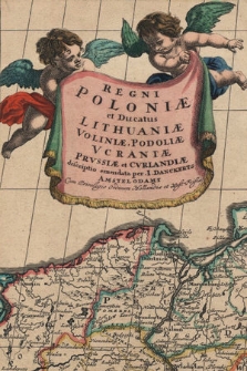
Tytuł: Regni Poloniae et Ducatus Lithuaniae, Voliniae, Podoliae, Ucraniae, Prussiae et Curlandiae
Miejsce wydania/powstania:
Uwagi:
Orientacja mapy północna ; Podziałka liniowa w milach niemieckich
Skala:
Źródło:
Biblioteka Jagiellońska, M 36/602
Identyfikator dokumentu cyfrowego:
NDIGKART001713 ; DIGKART000035
Zakres:
Język:
Status prawny:
Domena publiczna (public domain)
Lokalizacja oryginału:
Katalog komputerowy:
Format:
Identyfikator zasobu:
Źródło finansowania:
Kolekcje, do których przypisany jest obiekt:
- Jagiellońska Biblioteka Cyfrowa > Rodzaje zbiorów > Zbiory kartograficzne > Mapy
- Jagiellońska Biblioteka Cyfrowa > Projekty > EFRR POIiŚ 11.1
Data ostatniej modyfikacji:
9 maj 2023
Data dodania obiektu:
14 lip 2010
Liczba wyświetleń treści obiektu:
12 483
Liczba wyświetleń treści obiektu w formacie HTML
196
Wszystkie dostępne wersje tego obiektu:
https://jbc.bj.uj.edu.pl/publication/923
Wyświetl opis w formacie RDF:
Wyświetl opis w formacie OAI-PMH:
×